To read this month’s Newsletter click here 202005_nws_TT
Tableland Talk May 2020
Reply
To read this month’s Newsletter click here 202005_nws_TT


Map
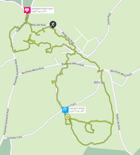
GPS coordinates -36.646502 145.026763
| Distance |
| 7km |
| Difficulty |
| Grade 3 |
| Duration |
| 3-4 hours (bushwalking) |
| Alternative Recreational Uses |
| Birdwatching, mountain biking, photographing, picnicking, orienteering and driving (on formed roads only). Prospecting and fossicking require a Miner’s Right.
Motor bikes / 4WDs must be registered, riders / drivers licensed & stay on formed roads. |
| Seasonal Information |
| Wildflowers in spring and autumn. Muddy tracks in winter. Very hot and dry in summer. |
| Cautions |
| The Information Centre is permanently closed.
Signs and trail markers may be damaged Unauthorised and poorly defined tracks and trails exist. Take care not to get lost! No potable water is available. No pets. Take your rubbish with you. Grass trees are vulnerable to cinnamon fungus transfer: keep to formed roads and tracks. |
| Amenities |
| Car parking, public toilets, picnic tables, fire grates, interpretive signs, trail markers and camping |
| Management and Support Groups |
| Parks Vic |
Location
To access the Whroo Historic Area, drive through the Rushworth State Forest via the Rushworth – Nagambie Rd. 7km south of Rushworth Township, turn left into Reedy Creek Rd. The central car park with public toilets is 0.5km from this intersection on the right.
Track Notes
This is often a quiet, empty place of bushland, native flora and fauna. Exploration of the Whroo Historic Trail unearths evidence of a different, busy, crowded and culturally significant past. The open cut of the impressive Balaclava Mine marks one end of the journey. Remnants of Victoria’s gold rush era can be discovered all along the way. Underground storage tanks, mining shafts and tunnels, building rubble and foundations, century old rubbish dumps and gold mining infrastructure comprise an historic treasure trove. Once spring fed Aboriginal rock wells close these historic trail loops.
You can enter the trail loops at any point. However, the sizable central car park with picnic and toilet facilities is probably the most convenient place to start and finish.
Head uphill to the right of the public toilets to join the Balaclava Mine section of the trail. The trail is well-defined, being constructed of a crushed quartz and gravel surface. Be wary, the gravel can slip. There are 2 viewing points into the open cut. Watch out for locked gated tunnels through the hill. The larger was for a tramline. Access into the open cut is now prohibited due to the high risk of rock falls.
After you pass the second viewing point, cross nearby Rushworth – Nagambie Rd to see the original battery dam. If you are lucky, you may see tortoise on the bank. Fish live in this water.
There is great mountain biking below the dam wall. Procced downhill parallel to the road while looking across the road to your left. Cross the road to the first trail on your left to rejoin the Balaclava Mine loop. You will return to the central car park via mullock heaps and the site of the Lewis homestead.
Once back at the central car park, this time head downhill, towards Whroo Cemetery. Keep to the left of the open grassy space you initially traverse. Imagine it humming with the sounds of a 10,000 strong population. Take care, like this space, some walking trails may not be well defined due to variable local conditions. You will arrive at a dirt road. Head along the road to your right to resume the trail on the opposite side, beside Poor Man’s Gully. Observe the mullock heaps of gold mining detritus as you pass by.
You will come to Cemetery Road. Cross here to follow the cemetery driveway into the cemetery itself. There are 400 graves here, many unmarked. Take time to reflect on the timing and causes of death in gold rush Whroo.
The next stop will be the Aboriginal waterholes. Follow the trail behind the cemetery around the base of the nearby low hill to the left of the cemetery. Passing through stands of grass trees, you will come to an intersection. Follow the trail marker on your left pointing up the hill. Cross the next dirt road to the ramp that leads to the waterholes.
Return back down the same trail section to the intersection and turn left to resume the trail. This will now run parallel with Reedy Lake Rd until it reaches Cemetery Rd. Cross to the picnic tables on the corner. To return to the central car park, continue uphill parallel to Reedy Lake Rd. You have completed your trail loops.
Options
Topography and Geology
Of the undulating rises to low hills, Balaclava Hill is the highest point in the Whroo district. It was a very rich mine. During the Silurian period, an intensely heated earth’s crust beneath the gold fields pushed volcanic rocks into extremely-hot salty water. As the water moved closer to the surface and cooled, gold crystallised out with quartz. 600 million years later, this resulted in a 19th century fortune of more than £1,000,000 from quartz bearing gold veins of up to 15cm across. Whroo goldfields are estimated to have produced 40,000 ounces of gold.
Flora
Whroo Historic Area comprises 490 hectares within the world’s largest ironbark forest of 24,300 hectares. The forest itself harbours a canopy of red and mugga ironbark, grey box, yellow box, white box and red stringy bark. The mid story contains grass trees, blackwood, golden wattle, spreading wattle, casuarina, melaleuca and dogwood. There are occasional patches of mallee. The understory consists of grevillia, drooping cassinia and bush pea. A ground layer of native grasses, woodland flowers including orchids and bulbous plants completes a unique native bush landscape.
Fauna
Kangaroos, wallabies, yellow footed antechinus, brush tailed phascogale, squirrel glider, common dunnart, legless lizards, tree goannas and tortoise may be spotted. Particularly, if you choose to camp overnight.
Birdlife
Rushworth State Forest is listed as an eBird Australia hotspot with records of 150 species, including the powerful owl and threatened swift parrot.
Local History
The Nguraililam-wurrung aboriginal people used ironbark forest timber to fashion canoes, hunting implements and construct shelters. Ironbark blossom made a sweet beverage. The name “Whroo” is said to come for the word meaning lips. This was a reference to the aboriginal watering holes in the area.
Gold was discovered in Rushworth in 1853. In 1854, a gold nugget was discovered in grass at Balaclava Hill by John Lewis and James Nickinson. The consequent goldrush lasted much of the decade, recurrently bringing thousands to try their luck. Gold mining began with alluvial diggings, proceeding to open cut methods as alluvial returns diminished. By 1860, a population of just 450 remained. The Balaclava Hill Mine continued to be productive until it was shut down in the 1870s due to water management problems. However, shafts have been mined since. The last active shaft was filled by the Mines Department in the 1960s.
In its time, the Whroo township accommodated a Mechanic’s Institute, a state school, a post office, a savings bank, a free library, 2 churches, 3 ore crushing mills, 3 hotels and a cordial factory. 139 buildings were still present in 1871.
Rumour has it Ned Kelly and his gang visited the area. Prior to anticipated trouble with the local constabulary, it is said a cache of Kelly gold was stashed in the area and never found again …..
Whroo cemetery reflects the undiscriminating difficulties of life in a harsh environment, where neither age, nationality, culture nor religion provided protection. Chinese miners make up 15% of those buried. They were a significant part of the community as miners, for operating puddling machines and growing market gardens.
However, by the 1920s ironbark timber cutting was the principal remaining industry. By 1933 the population had fallen to just 52. By 1955, Whroo was a ghost town.
In case of emergency
Call 000


Title
Melville’s Lookout Track
Map
Lat: 36.812930
Lon: 144.996363
Distance, Grading and Cautions
| Distance |
| 10.5km |
| Difficulty |
| Grade 3 |
| Duration |
| 3 – 4 hours bushwalking |
| Alternative Recreational Uses |
| This is a good location for multi recreational use: bushwalking, mountain bikes, orienteering, rogaining and driving (on formed roads only)
Horse riding, motor bikes and 4WDs are only permitted on formed roads. |
| Seasonal Information |
| Wildflowers in autumn and spring. Muddy tracks in winter. Very hot and dry in summer. |
| Cautions |
| Grass trees are vulnerable to cinnamon fungus transfer: keep to formed roads and tracks.
Unauthorised tracks exist. Take care not to get lost! No pets or firearms. No drones without a permit. Rough ground, snakes, falling limbs, no potable water. |
| Amenities |
| Picnic tables and fire grates at the Lookout |
| Management and Support Groups |
| Parks Vic |
Location
Embark from and return to the carpark (of sorts) on the corner of Mt Black Quarry Rd and Heathcote Nagambie Rd., Wirrate.
Track Notes
The main part of the track comprises Mt Black Quarry Rd. This is a dirt vehicle track with very little traffic. Take care, loose stones can make the track slippery. The track rises gently for 3.6km, where it arrives at the base of a steep, rough foot trail that ascends directly to the Lookout (at 4.2km). This foot trail then joins the dirt vehicle track on the opposite side of the summit. This dirt vehicle track loops back to the base of the hill. If the initial steep foot trail ascent looks too daunting, keep walking along the road approximately 100 metres until you get to the Melville’s Lookout 2km directional sign pointing left. Follow this track up and back down for a less demanding walk.
To the right of the Melville’s Lookout sign you will see remains of the old Goulburn Weir quarry site. Rocks from this location were cut to build the Goulburn River Weir wall at Nagambie in 1890. This area invites exploring. Kids will love it for all the climbing and hiding places. It makes for excellent mountain biking as well.
Options
Topography and Geology
The National Park is composed of forested hills and gullies. The sand stone ridge lines are a result of folds in the earth’s crust. Look out for fossilised sea shells from the ancient sea bed.
Flora
This park comprises Victoria’s largest remaining box – ironbark forest, consisting of open woodland including ironbark, grey and yellow box and stringy bark. The understory features blackwood, gold dust wattle, silver wattle and drooping cassinia. Grass trees are numerous. Green rock fern is a common ground plant in milder months.
Wildflowers include grassland wood sorrel, shiny everlastings, tall bluebells and Nodding Greenhood orchids, with many more according to the season. Rare spider orchids may be also found.
Fauna
Eastern Grey kangaroos and goannas may be encountered.
Threatened species you may be lucky enough to see are the tuan and swift parrot
Birdlife
White winged choughs love the ground layer and white throated tree creepers are commonly seen running up midstory trunks. Red and little wattle birds and parrots particularly enjoy the canopy when eucalypts are in flower. And, of course, cockatoos abound. If you keep your wits about you, there are plenty more birds to be seen.
Pests
Damage from 4WD and motorbikes is not as bad as elsewhere, but sadly some clowns will always take pleasure in littering and tearing such places up.
March flies can be a problem in Autumn.
Local History
Naming:
Dargile (formerly Heathcote – Graytown) National Park.
Melville’s Lookout: Captain (Francis) Melville was a notorious goldrush era bushranger. After being transported to Australia at age 15 for housebreaking, he escaped Port Arthur to live with local aborigines for a year. He came to Victoria in 1851. Within a short time he had formed the Mt Macedon Gang that robbed travellers heading to and from the goldfields.
a diet of nectar or insects provides for its high level of activity Continue reading
By tapping into a shaded public drinking fountain this Australian White Backed Magpie ensured itself a long, cool drink. Continue reading

This gallery contains 10 photos.
Walking these trails on a day such as this was a profoundly pleasurable experience. Continue reading
Holy smokes, Buttman!
Richard Squires has picked up nearly 50,000 butts around Melbourne over the past six months and wants everyone else to get in on the act.
http://www.theage.com.au/victoria/holy-smokes-buttman-the-man-on-a-mission-to-rid-the-city-of-cigarette-butts-20200227-p5450v.html?btis
Click on the link for this month’s issue: 202003_nws_TT.pdf
Previously, Mt Black Flora Reserve, now Dargile (Heathcote-Graytown) National Park (12,833ha).


Responsible Authority
Parks Vic
Acceptable modes of transit:
Foot, mountain bike, horseback, car
GPS coordinates & map
Lat -36.812552 Long 144.996543

Distance & duration
10.5km, 4 hours
Grading (using the Parks Vic Track and Trail Grading Manual):
Grade 3
Amenities:
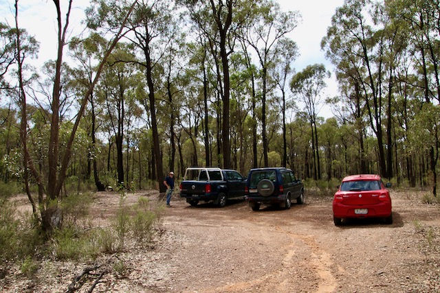
The lookout has 2 picnic tables and 2 fire places
There is evidence of camping
Hazards
Limbs may fall, snakes, rough ground
Very loose stones on the steep ascent to Melville Lookout
No drinking water is available
There are multiple unsigned branching trails. Getting lost is a risk.
Restrictions
No dogs, cats, pets allowed
No firearms allowed
No drones without a permit
Trailhead & Informational Signs
There is no trailhead sign present
Directional signs / bollards or trail markers


The Melville lookout sign at the summit is damaged
There are no trail markers
Brochure (using the existing SRCMN / Strathbogie Shire format)
None available
Recommended works
Required
Improvement in trailhead and directional signs
Suggested
Development of designated car parking spaces at trailhead and base of trail up to Melville’s Lookout.
Littering and rubbish dumping clean up.
Conclusion
This is an established trail in current use. It has capacity for multi recreational use. There are several features of interest to make it worthy of promotion.

This gallery contains 2 photos.
We are seeing Little Corellas in all sorts of places around the state now Continue reading
 Within a second of this adult male Dusky Moorhen emerging from the water, the juvenile had pounced, snatched and was swimming off at a rate of knots.
Their hands when they touch
Flow from rolling of wrists
Each touch is a signal
Each touch is a kiss
Their fingers are folding
On whispers and secrets
Cupped hands are holding
All ahead that will be
Their fingers trace circles
On their palms telling futures
Tender are the touches
Of their hands as their tutors
Their hands rest together
One on top of the other
Their hands mark their measure
Their harmonious hands
Their hands spread out
Open and true
Telling each story
Each soul on view
Hands hold each heart
Supporting each core
Their hands do the learning
Of what more to adore
The extension of hands
The parallel lines
Pads of sensitive fingers
Their dreaming defines
There are fists and shaking
There are dips and rise
There are quivering fingers
Before flickering eyes
When hands arc with arms
To gracious embrace
The lovers say nothing
As hands touch each face
Delicate lines are drawn
Across soft skinned cheeks
Then with touches to lips
Mouths start to seek
Two seeing hands
guide the blind
Sensuous and caressing they massage
Four hands synchronise
to breathe in kind
Entwined
in waves of love
It is a small town with a small Newsletter, but we like it. Click here: 202002_nws_TT
Testament to our past misdeeds
Confirmation of future trends
For victims, my heart bleeds
No politics justify these ends
The smoke filled sky blocks light and hope
Destruction and death follow
How will our burning country cope?
What hope is there for tomorrow?
Immediate danger on fire grounds
A fire season now six months long
Environmental disaster all around
We need more than just “stay strong!”
Adopt the fire advice “watch and act”
For this escalating climate emergency
Because if a nation ablaze isn’t enough fact
Our destiny is to burn again too blind to see
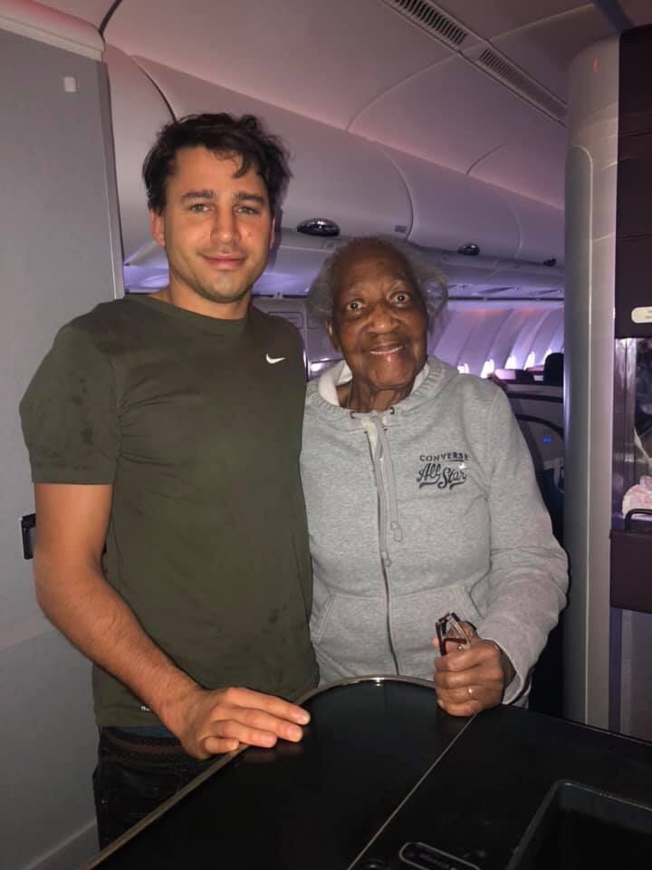
They met before the air, when the air was to be sky
An aged lifetime dreamer met a genuinely considerate guy
Who met an elderly woman, with a strong desire to fly
He gave up first class to her, she gave a pleased and grateful sigh
Violet, eighty-eight, could afford an economy ticket
Jack had first class for his whole family to wing it
Both were going London to New York in early December
She with no flight priors, this special first to remember
He knew this from chatting to her in the airport lounge
This was her first overseas flight, to her daughter bound
She told of her grief at the family departure and long absence
And her last chance to see their new American residence
Jack told his wife of Violet’s anticipation, joy and excitement
He wanted to add more to what this flight already meant
He gave up his seat berthed next to his own family
That she could travel verily to her family comfortably
And the stewards said it felt lovely, it was the sweetest thing
To take her photo up front while in first class she winged
An image for her daughter to see, who may not have believed
And for Jack as a memento of the pleasure given and received
For it wasn’t just the ticket, the seat or the price
It was the face of human kindness that was so wonderfully nice
Everyone who observed was touched by his gesture
Everyone was reminded what in a person should be measured
Seeking out what is good is the measure to be treasured
Good on you Jack
Click on the link: Tableland Talk, December 2019
I love to sit by Rosella Highway
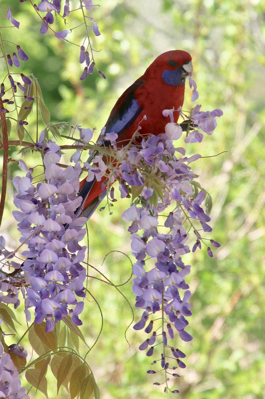 When a crimson flash drives my way
A dip, a rise, a lateral meander
Arcing right to pass our verandah
Cutting the corner, just by my head
Blurred red into blue the colours bled
A wind that brushes across my cheek
As the rushing parrots charge by to seek
Fields of grain, seed and fruit
Forests of buds and flowers to loot
Friends and family travel in flocks
Adults school juveniles in hard knocks
That clearly dictate the pecking order
While traversing landscapes without border
Their 3D byways criss cross the land
Enhanced and encumbered by rise of man
They flit up to perch on the highest limb
They dive deep to drop to waters brim
I watch with envy this life of pleasure
By which I set my life to measure
Views of the world I’ll never see
From high above and in canopy
Agile aerialist sky bourne of air
Fortunate bird without a care

This gallery contains 88 photos.
Originally posted on Strathbogie Ranges – Nature View:
With over 80 sculptures on display, ranging from the size of an egg to 2.5 metres high, there was plenty to see.
This gallery contains 10 photos.
Originally posted on Strathbogie Ranges – Nature View:
As part of the Strathbogie Arts Festival by BogArts, many artists contributed to an Ephemeral Sculpture Walk along the Bridge to Bridge walking track. The challenge was to construct works from degradable…
Responsible Authority:
Acceptable modes of transit:
Walk
Distance & duration
GPS coordinates & map
 Grading (using the Parks Vic Track and Trail Grading Manual)
Grade 5
Amenities:
None
Hazards
Snakes, tree and limb falls, very steep inclines, cliff faces, overhangs, steep embankments, slippery surfaces include wet surfaces, loose rocks, soil, mud and vegetation, absence of pathways, flowing water
Restrictions
Trailhead sign & Informational Signs
None (Mt Hut Reservoir, GV Water sign at gate)
Directional signs / bollards or trail markers
None
Brochure
None.
Recommendations
Significant sections of this walk are a scramble through steep bush terrain. Trail marking and eventual foot trail creation would improve access and safety.
Conclusion
For experienced, well prepared hikers only. A service track begins at and returns to the Mt Hut Reservoir GV Water gate on the Euroa-Strathbogie Road, but only goes as far as Mountain Hut Creek Reservoir itself. From here you follow the Mountain Hut Creek embankment to Waterhouse Reservoir. At this point, cross the dam wall and once again proceed upwards, around the Reservoir and again onto the creek embankment. There is no trail, the slopes are steep and littered with loose surface material. Take care. However, the reward is great. Charman’s Falls are spectacular, particularly with a good spill of water, and it is downhill all the way back.
Give deodands and pennies for eyes
Slake the thirst and feast who dies
Then turn to home, to humble pies
Beget, begone, say your goodbyes
In forgiveness, honour, deposit the dead
Who in pious mercy, give up their dread
As the vehicle of loss to heaven we send
That god receives to make amends
There were two of us
We were young
We didn’t really know each other
Just of each other
Through others
But somehow we knew we were for each other
At some point it became clear
And then it became necessary to test it
And then it became essential
And the knowing was certain
Intuitive
Two became one
It wasn’t part of any plan
To fall in love
I guess that is why it is called falling
You find yourself tumbling head over heels
an uncontrolled free-fall
Preoccupied, whimsical, looking forward to next time.
Wanting next time to never end
Smiling when you are alone
Smiling when together
Just smiling in general
I’m smiling now
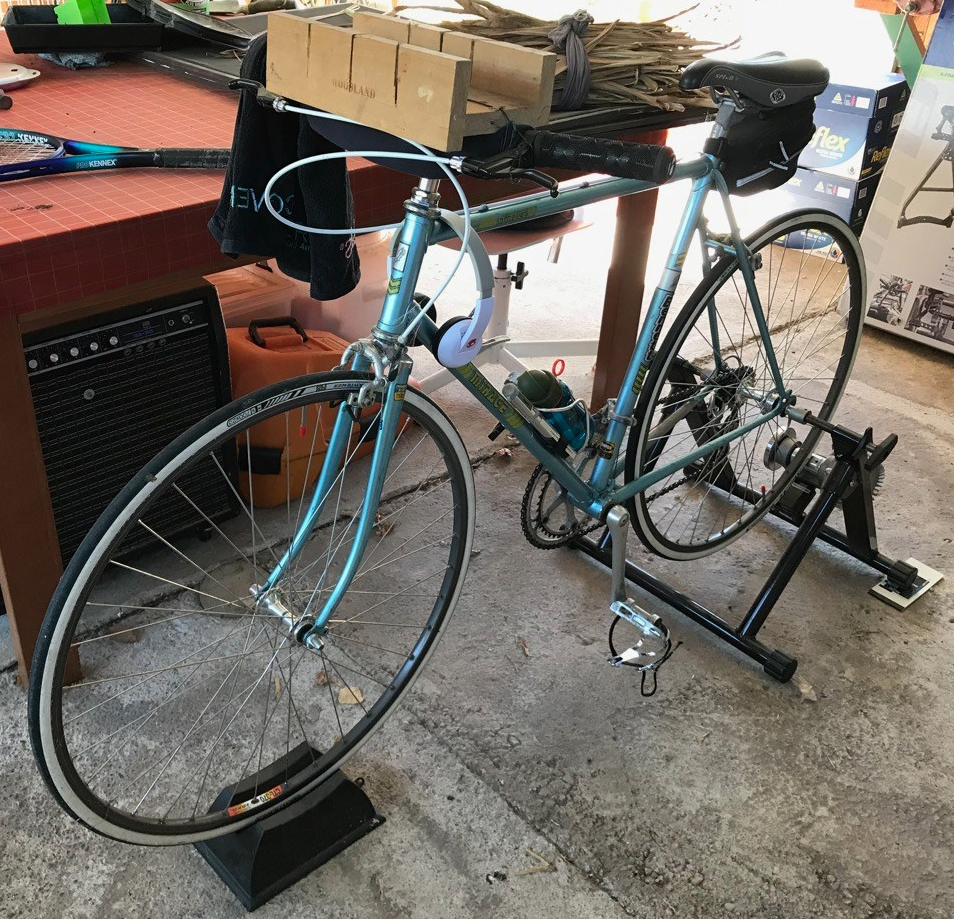
I’m sitting on my bike feeling like an athlete
Pumping on the pedals pushing hard with two feet
Think I’m 21, not true but it would be so sweet
Trying to stretch my body to a 60+ life cheat
The wheels below me spin going nowhere above the concrete floor
The resistance trainer squeals getting hotter at its core
Parrots on the outside watch me through the open door
As I sweat and puff and grip to gain a minute more
I took the vow on January 1 a New Years resolution
To plan a longer fuller life a Seaniverse solution
Write a recipe to follow to my end of days conclusion
For what it’s worth I thought I’d share it take or leave my proposition
Health and happiness can be elusive when ageing as I am
Failing mind and body are inevitable and then bam
You die a death one way or another no way to stop it man
So get there smart, sharing and active as best you can
You can’t be everything to everybody but you can share with a few
You can’t extend beyond your limits but there may be limits you never knew
You can be concerned about the future or plan for it ahead
It may not work the way you planned but that’s an opportunity instead
So here’s the recipe for trying it’s not really all that hard
It’s based on good and bad experience, read from lots of greeting cards
Exercise mind and body, I run walk ride read and write
Consciously enjoy the present, there’s no point worrying through the night
Appreciate the world around you mindfully it’s the only way that’s right
Action your ideas, you’ll feel sharp and crisp and bright
Socialise with others in ways appropriate for each
Permit allow enjoy, calm rest and sleep makes life a beach
A considered “Yes” is the right answer almost every time
Follow these simple rules to be secure and feeling fine
It’s EEAASSY
I do appreciate for some it is not so easy, health of mind and body are fragile things, security can be a fragile thing. My best wishes to you all. I hope, possibly, maybe something above can be of assistance somewhere, sometime.
The awareness that comes to us via consciousness and the tool of language suggests to many of us there is a point to our existence
However, there is no rational justification for this view
In a very complicated way
Human existence simply happened
It has no intrinsic need of purpose or explanation
It is our egos that ask for that
It is the same for all of us
Human existence manifests as human living
Neither has any point to it
No enduring purpose other than as a fact to be accepted,
Or, possibly as an exclusive point in its own right
As an optimist, I choose the second version of what is essentially the same thing
Although I am unsure what this implies regarding longevity
As it still suggests much is futile
Because the longer each of us lives the more we understand human nature
Consequent behaviours replay across history for better and worse
Same dreams, hopes, ambitions
Same responses, actions, strategies
Same reactionary outcomes that trend toward destruction
To the extent, we often ask why bother?
Well, I guess we might as well
So, “Does it matter?” becomes redundant
Even if meaning could be universally applied
Lack of comprehension regarding our beginning and knowledge of the inevitable end render meaning meaningless
There can be no result, no understanding to be gleaned, no purpose
So where is the point of human living?
In the scheme of things (that doesn’t exist) it doesn’t matter whether you live or not,
But at least you get to choose
You either might as well or not
I choose to live for the transient pleasure of it, the observation, the feeling of it, the moments of joy, the acknowledgement that consciousness came to be and will come to pass, the participation, the experience of love, for being here now – if you like that set of clichés
However, the future is a place of little significance to me other than to say I would hope for my family and coming generations to also have the necessary security to enable them to share the ephemeral opportunity to appreciate being
Such a curious legacy of hope begot from my love
Trail Checklist
Name:

Responsible Authorities:
Acceptable modes of transit:
Distance & duration
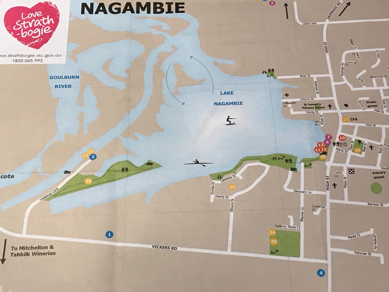
GPS coordinates & map
36°47’07.8″S 145°09’11.0″E
-36.785508, 145.153068
 Grading (using the Parks Vic Track and Trail Grading Manual):
Grade 2
Amenities:
Hazards
Snakes, slippery surfaces, embankments, falling trees and limbs, deep water
Restrictions
Trailhead sign
Informational Signs
Directional signs / bollards or trail markers
Conclusion
This pleasant walk is in current use and offers many amenities to visitors. A feature map brochure, separate to the Nagambie Tourist Map and including the Regatta Centre Walk, would encourage more people to extend their visit beyond just looking over the Lake from High Street.

