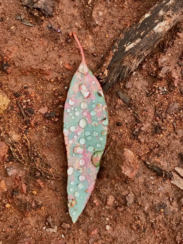
I am trying to learn the names of the local wildflowers as I walk. I was surprised to find so many on Hughes Creek Hill in mid winter. The file names are what I think these are. Corrections welcome. There is also one unknown I need assistance with.


I am trying to learn the names of the local wildflowers as I walk. I was surprised to find so many on Hughes Creek Hill in mid winter. The file names are what I think these are. Corrections welcome. There is also one unknown I need assistance with.
“It is above all by the imagination that we achieve perception and compassion and hope.”
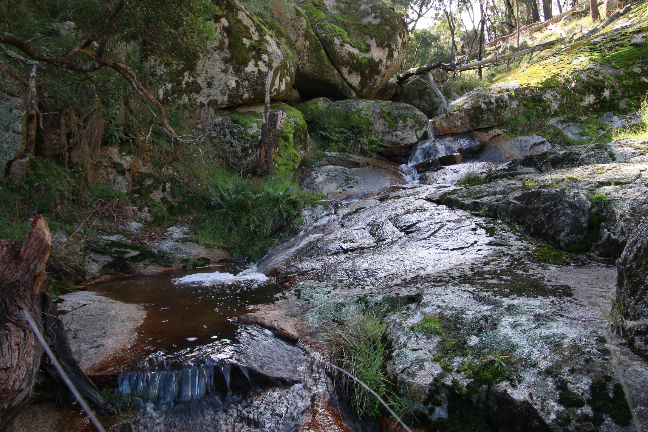
Wallaby Gully, Upton Hill has the cutest little stream.
Am I really
the one you see?
Or do you superimpose
someone else
over me?
Someone
I will never agree
to be
In your expectation
I will
dutifully
bend to your will
as a vassal
bends the knee
That’s not really me,
part of your hegemony.
Just now I need you
you see.
But, my duty to you
is not my duty to me.
As I strive for self determination
and security.
My left wrist between your breasts
My left hand upon your chest
My left forearm lies across your left ribs
My left elbow beside your abdomen
My left bicep hugs your flank
My left temple on your left shoulder blade
My chest against you back
Your buttocks cushion my groin
My quads align with the back of your thighs
The front of my knees inside the back of your knees
My tibia parallel your calves
Your soles rest softly on the dorsal aspects of my feet
Your soul binds my heart
A nice little newsletter from a nice little place.
Believe in me, believe in me, believe in me
Said each of the the guiltless emphatically
Ministers in the State Labor Party
Said each of the blameless emphatically
Ministers in the Federal Coalition Parties
We’ll create a safe and free society
Where rule of law and democracy
Are the state of play and how it should be
Trust in us, trust in us, trust in us
To build a world of justice without the fuss
Where all are equal and none are hushed
None are corrupted by power lust
Faith and hope, faith and hope, faith and hope
To save the civilised world, give us enough rope
See us tie it in knots and we’ll see how you cope
See us twist it and turn it, make it slippery with soap
Deceit and lies, deceit and lies, deceit and lies
We’re the cream at the top of reformist deniers
We laugh as the piss weak we hang out to dry
As our robodebts and branch stacking see due process die
Watch and despair, watch and despair, watch and despair
As we bring down noble institutions without a care
As we turn our society into one where no one will share
As we promote vested interests beyond repair
Our connections to the world outside
Digital threads off the Tableland
Are brittle lines
That disappear into the ether
Whispers into the virtual world
Where they really go
I don’t know
I find an number, a url, an IP address
and click
To send or receive
My message goes out to somewhere
A response comes back from somewhere
So distant, is it real, this ethereal contact?
As real as a handshake, a hug or a kiss?

I love the tang of a tomato
As it tickles the taste buds on my tongue
There’s nothing quite like the tingle
As the juice begins to run
The pop of the first bite
The explosive gush of taste
When I eat a tomato
Not one bit do I waste
I wonder what it is I see you for
When all I crave is to see you more
There’s your smell I can’t resist
My melting heart after we’ve kissed
Your fingertip pressure upon my spine
Body electric your touch divine
The texture of your warm soft skin
The brush and rush of lovemaking
The way you walk and swing your hips
The way you talk with precious lips
Your voice a sound of sweetest measure
The sound of true love‘s spoken pleasure
The way you think and make me wonder
You shake my world, views torn asunder
And when you challenge it stirs in me
New hope and ways that I can see
Your hair holds aloft a thorny crown
You turn the wind right way around
Your shoulders strong they carry me
Arms embrace me meaningfully
Our limbs entwined our hearts on fire
Together, inspired, alight, desire
When your nose nuzzles my neck
I feel the comfort of a future set
The deep, dark pools behind your eyes
They drive me to resist good byes
I love to love you in every way
I need to see you every day
These are the reasons
Y I C U

The sea the sea the rolling sea
Is all that I adore
Let me let me be upon the sea
Mother dear, I implore
Beside stern lantern’s fading light
I’ll wave to fading shore
To sail away year and day
And learn the ocean lore
A seaman right and able I’ll be
A landsman never more
This can be a challenging, but gorgeous walk anytime. However, when in flood it is an amazing place for chuting with daggers as well.
I met these guys at Polly’s one year as they were preparing to take on the large number of falls and cascades in these highly manoeuvrable kayaks. They watch BOM for a certain flood level as a trigger point to take on the raging water. They emphasised this was only something to do when the water level was right. Otherwise, the risk of disaster was manyfold higher.
I hadn’t seen the video until Sim posted it on bogietree enjoy: shooting the flooded Sevens
Vonnie sent me this lovely poem after seeing my recent post about Whroo Historic Area. It has been a favourite site for her and husband Graham over the years. I can see why. I have Vonnie’s permission to reproduce it here.
This place is littered with broken brick,
discarded bits of crockery,
signs that once this was a home
to those who dug for gold.
They have been gone a long time now –
gone with the spoils of their sojourn –
leaving the bush, now done with,
to its thoughts.
Neglected fruit trees struggle to survive,
the wells are dry and mine shafts filled
with rubbish and with rubble;
peppercorns droop,
their pale pink seed pods dangle,
their spicy scent hangs in the warming morning;
tired pines lean into afternoon
with limbs like old bones, twisted.
Absence has brought wildflowers to
the graves within the little cemetery –
bindweed and finger flowers are bright
against the dusty ground;
the headstones slump and mutely spell out
lives in gaining spent.
The ironbarks have staked their claim;
the native cherry and the wattle stand
amongst the straggling Chinese scrub;
mounds of mullock have grassed over and
the hard earth, spread with scats,
is rich again with golden everlastings.
Choughs in dozens protest at approach;
loudly, harshly they insist
this place of strange abandoned beauty
is their territory.
To read this month’s Newsletter click here 202005_nws_TT


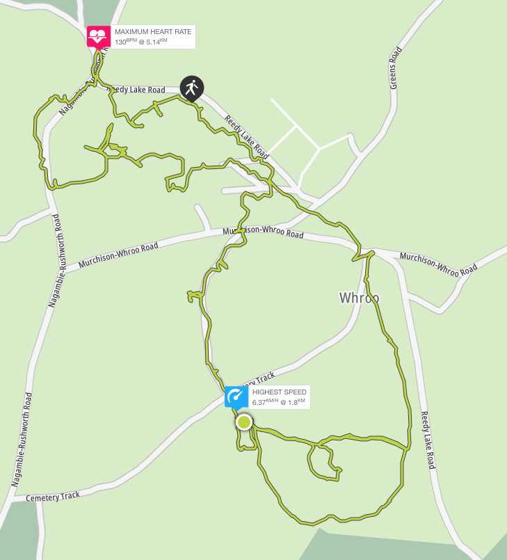
Map
GPS coordinates -36.646502 145.026763
| Distance |
| 7km |
| Difficulty |
| Grade 3 |
| Duration |
| 3-4 hours (bushwalking) |
| Alternative Recreational Uses |
| Birdwatching, mountain biking, photographing, picnicking, orienteering and driving (on formed roads only). Prospecting and fossicking require a Miner’s Right.
Motor bikes / 4WDs must be registered, riders / drivers licensed & stay on formed roads. |
| Seasonal Information |
| Wildflowers in spring and autumn. Muddy tracks in winter. Very hot and dry in summer. |
| Cautions |
| The Information Centre is permanently closed.
Signs and trail markers may be damaged Unauthorised and poorly defined tracks and trails exist. Take care not to get lost! No potable water is available. No pets. Take your rubbish with you. Grass trees are vulnerable to cinnamon fungus transfer: keep to formed roads and tracks. |
| Amenities |
| Car parking, public toilets, picnic tables, fire grates, interpretive signs, trail markers and camping |
| Management and Support Groups |
| Parks Vic |
Location
To access the Whroo Historic Area, drive through the Rushworth State Forest via the Rushworth – Nagambie Rd. 7km south of Rushworth Township, turn left into Reedy Creek Rd. The central car park with public toilets is 0.5km from this intersection on the right.
Track Notes
This is often a quiet, empty place of bushland, native flora and fauna. Exploration of the Whroo Historic Trail unearths evidence of a different, busy, crowded and culturally significant past. The open cut of the impressive Balaclava Mine marks one end of the journey. Remnants of Victoria’s gold rush era can be discovered all along the way. Underground storage tanks, mining shafts and tunnels, building rubble and foundations, century old rubbish dumps and gold mining infrastructure comprise an historic treasure trove. Once spring fed Aboriginal rock wells close these historic trail loops.
You can enter the trail loops at any point. However, the sizable central car park with picnic and toilet facilities is probably the most convenient place to start and finish.
Head uphill to the right of the public toilets to join the Balaclava Mine section of the trail. The trail is well-defined, being constructed of a crushed quartz and gravel surface. Be wary, the gravel can slip. There are 2 viewing points into the open cut. Watch out for locked gated tunnels through the hill. The larger was for a tramline. Access into the open cut is now prohibited due to the high risk of rock falls.
After you pass the second viewing point, cross nearby Rushworth – Nagambie Rd to see the original battery dam. If you are lucky, you may see tortoise on the bank. Fish live in this water.
There is great mountain biking below the dam wall. Procced downhill parallel to the road while looking across the road to your left. Cross the road to the first trail on your left to rejoin the Balaclava Mine loop. You will return to the central car park via mullock heaps and the site of the Lewis homestead.
Once back at the central car park, this time head downhill, towards Whroo Cemetery. Keep to the left of the open grassy space you initially traverse. Imagine it humming with the sounds of a 10,000 strong population. Take care, like this space, some walking trails may not be well defined due to variable local conditions. You will arrive at a dirt road. Head along the road to your right to resume the trail on the opposite side, beside Poor Man’s Gully. Observe the mullock heaps of gold mining detritus as you pass by.
You will come to Cemetery Road. Cross here to follow the cemetery driveway into the cemetery itself. There are 400 graves here, many unmarked. Take time to reflect on the timing and causes of death in gold rush Whroo.
The next stop will be the Aboriginal waterholes. Follow the trail behind the cemetery around the base of the nearby low hill to the left of the cemetery. Passing through stands of grass trees, you will come to an intersection. Follow the trail marker on your left pointing up the hill. Cross the next dirt road to the ramp that leads to the waterholes.
Return back down the same trail section to the intersection and turn left to resume the trail. This will now run parallel with Reedy Lake Rd until it reaches Cemetery Rd. Cross to the picnic tables on the corner. To return to the central car park, continue uphill parallel to Reedy Lake Rd. You have completed your trail loops.
Options
Topography and Geology
Of the undulating rises to low hills, Balaclava Hill is the highest point in the Whroo district. It was a very rich mine. During the Silurian period, an intensely heated earth’s crust beneath the gold fields pushed volcanic rocks into extremely-hot salty water. As the water moved closer to the surface and cooled, gold crystallised out with quartz. 600 million years later, this resulted in a 19th century fortune of more than £1,000,000 from quartz bearing gold veins of up to 15cm across. Whroo goldfields are estimated to have produced 40,000 ounces of gold.
Flora
Whroo Historic Area comprises 490 hectares within the world’s largest ironbark forest of 24,300 hectares. The forest itself harbours a canopy of red and mugga ironbark, grey box, yellow box, white box and red stringy bark. The mid story contains grass trees, blackwood, golden wattle, spreading wattle, casuarina, melaleuca and dogwood. There are occasional patches of mallee. The understory consists of grevillia, drooping cassinia and bush pea. A ground layer of native grasses, woodland flowers including orchids and bulbous plants completes a unique native bush landscape.
Fauna
Kangaroos, wallabies, yellow footed antechinus, brush tailed phascogale, squirrel glider, common dunnart, legless lizards, tree goannas and tortoise may be spotted. Particularly, if you choose to camp overnight.
Birdlife
Rushworth State Forest is listed as an eBird Australia hotspot with records of 150 species, including the powerful owl and threatened swift parrot.
Local History
The Nguraililam-wurrung aboriginal people used ironbark forest timber to fashion canoes, hunting implements and construct shelters. Ironbark blossom made a sweet beverage. The name “Whroo” is said to come for the word meaning lips. This was a reference to the aboriginal watering holes in the area.
Gold was discovered in Rushworth in 1853. In 1854, a gold nugget was discovered in grass at Balaclava Hill by John Lewis and James Nickinson. The consequent goldrush lasted much of the decade, recurrently bringing thousands to try their luck. Gold mining began with alluvial diggings, proceeding to open cut methods as alluvial returns diminished. By 1860, a population of just 450 remained. The Balaclava Hill Mine continued to be productive until it was shut down in the 1870s due to water management problems. However, shafts have been mined since. The last active shaft was filled by the Mines Department in the 1960s.
In its time, the Whroo township accommodated a Mechanic’s Institute, a state school, a post office, a savings bank, a free library, 2 churches, 3 ore crushing mills, 3 hotels and a cordial factory. 139 buildings were still present in 1871.
Rumour has it Ned Kelly and his gang visited the area. Prior to anticipated trouble with the local constabulary, it is said a cache of Kelly gold was stashed in the area and never found again …..
Whroo cemetery reflects the undiscriminating difficulties of life in a harsh environment, where neither age, nationality, culture nor religion provided protection. Chinese miners make up 15% of those buried. They were a significant part of the community as miners, for operating puddling machines and growing market gardens.
However, by the 1920s ironbark timber cutting was the principal remaining industry. By 1933 the population had fallen to just 52. By 1955, Whroo was a ghost town.
In case of emergency
Call 000


Title
Melville’s Lookout Track
Map
Lat: 36.812930
Lon: 144.996363
Distance, Grading and Cautions
| Distance |
| 10.5km |
| Difficulty |
| Grade 3 |
| Duration |
| 3 – 4 hours bushwalking |
| Alternative Recreational Uses |
| This is a good location for multi recreational use: bushwalking, mountain bikes, orienteering, rogaining and driving (on formed roads only)
Horse riding, motor bikes and 4WDs are only permitted on formed roads. |
| Seasonal Information |
| Wildflowers in autumn and spring. Muddy tracks in winter. Very hot and dry in summer. |
| Cautions |
| Grass trees are vulnerable to cinnamon fungus transfer: keep to formed roads and tracks.
Unauthorised tracks exist. Take care not to get lost! No pets or firearms. No drones without a permit. Rough ground, snakes, falling limbs, no potable water. |
| Amenities |
| Picnic tables and fire grates at the Lookout |
| Management and Support Groups |
| Parks Vic |
Location
Embark from and return to the carpark (of sorts) on the corner of Mt Black Quarry Rd and Heathcote Nagambie Rd., Wirrate.
Track Notes
The main part of the track comprises Mt Black Quarry Rd. This is a dirt vehicle track with very little traffic. Take care, loose stones can make the track slippery. The track rises gently for 3.6km, where it arrives at the base of a steep, rough foot trail that ascends directly to the Lookout (at 4.2km). This foot trail then joins the dirt vehicle track on the opposite side of the summit. This dirt vehicle track loops back to the base of the hill. If the initial steep foot trail ascent looks too daunting, keep walking along the road approximately 100 metres until you get to the Melville’s Lookout 2km directional sign pointing left. Follow this track up and back down for a less demanding walk.
To the right of the Melville’s Lookout sign you will see remains of the old Goulburn Weir quarry site. Rocks from this location were cut to build the Goulburn River Weir wall at Nagambie in 1890. This area invites exploring. Kids will love it for all the climbing and hiding places. It makes for excellent mountain biking as well.
Options
Topography and Geology
The National Park is composed of forested hills and gullies. The sand stone ridge lines are a result of folds in the earth’s crust. Look out for fossilised sea shells from the ancient sea bed.
Flora
This park comprises Victoria’s largest remaining box – ironbark forest, consisting of open woodland including ironbark, grey and yellow box and stringy bark. The understory features blackwood, gold dust wattle, silver wattle and drooping cassinia. Grass trees are numerous. Green rock fern is a common ground plant in milder months.
Wildflowers include grassland wood sorrel, shiny everlastings, tall bluebells and Nodding Greenhood orchids, with many more according to the season. Rare spider orchids may be also found.
Fauna
Eastern Grey kangaroos and goannas may be encountered.
Threatened species you may be lucky enough to see are the tuan and swift parrot
Birdlife
White winged choughs love the ground layer and white throated tree creepers are commonly seen running up midstory trunks. Red and little wattle birds and parrots particularly enjoy the canopy when eucalypts are in flower. And, of course, cockatoos abound. If you keep your wits about you, there are plenty more birds to be seen.
Pests
Damage from 4WD and motorbikes is not as bad as elsewhere, but sadly some clowns will always take pleasure in littering and tearing such places up.
March flies can be a problem in Autumn.
Local History
Naming:
Dargile (formerly Heathcote – Graytown) National Park.
Melville’s Lookout: Captain (Francis) Melville was a notorious goldrush era bushranger. After being transported to Australia at age 15 for housebreaking, he escaped Port Arthur to live with local aborigines for a year. He came to Victoria in 1851. Within a short time he had formed the Mt Macedon Gang that robbed travellers heading to and from the goldfields.
a diet of nectar or insects provides for its high level of activity Continue reading
By tapping into a shaded public drinking fountain this Australian White Backed Magpie ensured itself a long, cool drink. Continue reading

This gallery contains 10 photos.
Walking these trails on a day such as this was a profoundly pleasurable experience. Continue reading
Holy smokes, Buttman!
Richard Squires has picked up nearly 50,000 butts around Melbourne over the past six months and wants everyone else to get in on the act.
http://www.theage.com.au/victoria/holy-smokes-buttman-the-man-on-a-mission-to-rid-the-city-of-cigarette-butts-20200227-p5450v.html?btis
Click on the link for this month’s issue: 202003_nws_TT.pdf
Previously, Mt Black Flora Reserve, now Dargile (Heathcote-Graytown) National Park (12,833ha).


Responsible Authority
Parks Vic
Acceptable modes of transit:
Foot, mountain bike, horseback, car
GPS coordinates & map
Lat -36.812552 Long 144.996543

Distance & duration
10.5km, 4 hours
Grading (using the Parks Vic Track and Trail Grading Manual):
Grade 3
Amenities:
The lookout has 2 picnic tables and 2 fire places
There is evidence of camping
Hazards
Limbs may fall, snakes, rough ground
Very loose stones on the steep ascent to Melville Lookout
No drinking water is available
There are multiple unsigned branching trails. Getting lost is a risk.
Restrictions
No dogs, cats, pets allowed
No firearms allowed
No drones without a permit
Trailhead & Informational Signs
There is no trailhead sign present
Directional signs / bollards or trail markers


The Melville lookout sign at the summit is damaged
There are no trail markers
Brochure (using the existing SRCMN / Strathbogie Shire format)
None available
Recommended works
Required
Improvement in trailhead and directional signs
Suggested
Development of designated car parking spaces at trailhead and base of trail up to Melville’s Lookout.
Littering and rubbish dumping clean up.
Conclusion
This is an established trail in current use. It has capacity for multi recreational use. There are several features of interest to make it worthy of promotion.

This gallery contains 2 photos.
We are seeing Little Corellas in all sorts of places around the state now Continue reading
