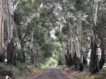
This gallery contains 10 photos.
Walking these trails on a day such as this was a profoundly pleasurable experience. Continue reading
This gallery contains 10 photos.
Walking these trails on a day such as this was a profoundly pleasurable experience. Continue reading
Previously, Mt Black Flora Reserve, now Dargile (Heathcote-Graytown) National Park (12,833ha).


Responsible Authority
Parks Vic
Acceptable modes of transit:
Foot, mountain bike, horseback, car
GPS coordinates & map
Lat -36.812552 Long 144.996543

Distance & duration
10.5km, 4 hours
Grading (using the Parks Vic Track and Trail Grading Manual):
Grade 3
Amenities:
The lookout has 2 picnic tables and 2 fire places
There is evidence of camping
Hazards
Limbs may fall, snakes, rough ground
Very loose stones on the steep ascent to Melville Lookout
No drinking water is available
There are multiple unsigned branching trails. Getting lost is a risk.
Restrictions
No dogs, cats, pets allowed
No firearms allowed
No drones without a permit
Trailhead & Informational Signs
There is no trailhead sign present
Directional signs / bollards or trail markers


The Melville lookout sign at the summit is damaged
There are no trail markers
Brochure (using the existing SRCMN / Strathbogie Shire format)
None available
Recommended works
Required
Improvement in trailhead and directional signs
Suggested
Development of designated car parking spaces at trailhead and base of trail up to Melville’s Lookout.
Littering and rubbish dumping clean up.
Conclusion
This is an established trail in current use. It has capacity for multi recreational use. There are several features of interest to make it worthy of promotion.

This gallery contains 88 photos.
Originally posted on Strathbogie Ranges – Nature View:
With over 80 sculptures on display, ranging from the size of an egg to 2.5 metres high, there was plenty to see.
This gallery contains 10 photos.
Originally posted on Strathbogie Ranges – Nature View:
As part of the Strathbogie Arts Festival by BogArts, many artists contributed to an Ephemeral Sculpture Walk along the Bridge to Bridge walking track. The challenge was to construct works from degradable…
Trail Checklist
Name:

Responsible Authorities:
Acceptable modes of transit:
Distance & duration
GPS coordinates & map
36°47’07.8″S 145°09’11.0″E
-36.785508, 145.153068
 Grading (using the Parks Vic Track and Trail Grading Manual):
Grade 2
Amenities:
Hazards
Snakes, slippery surfaces, embankments, falling trees and limbs, deep water
Restrictions
Trailhead sign
Informational Signs
Directional signs / bollards or trail markers
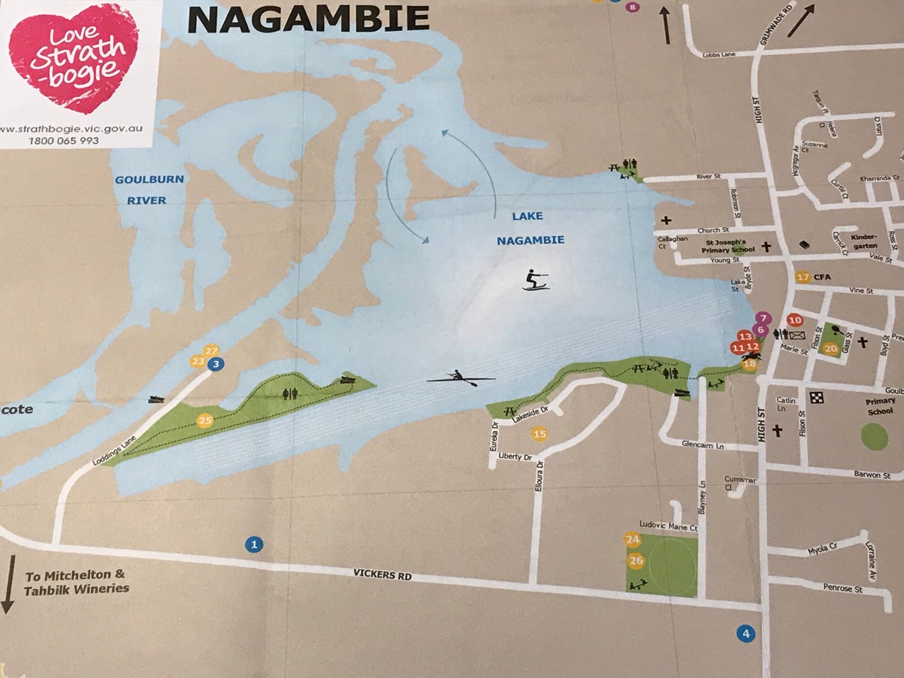
Conclusion
This pleasant walk is in current use and offers many amenities to visitors. A feature map brochure, separate to the Nagambie Tourist Map and including the Regatta Centre Walk, would encourage more people to extend their visit beyond just looking over the Lake from High Street.
Trail Checklist
Name:
Honeysuckle Creek Walk, Violet Town

Responsible Authority:
Authorities
Community
Acceptable modes of transit:
Distance & duration
GPS coordinates & map
36°38’01.0″S 145°43’05.8″E
-36.633606, 145.718286

Grading (using the Parks Vic Track and Trail Grading Manual):
Amenities:
Hazards
Snakes, tree and limb falls, flowing water, uneven ground and slippery surfaces
Restrictions
Trailhead sign
Directional signs / bollards or trail markers
Conclusion
This is an established, easy, bushy parkland walk with options for longer or shorter loops available. It is currently in frequent use by the public.
Trail Checklist
Name:
Reedy Lake Wildlife Reserve, Kirwan’s Bridge

Responsible Authority:
Community
Acceptable modes of transit:
Distance & duration
GPS coordinates & map
36°43’31.4″S 145°07’13.8″E
-36.725397, 145.120493

Grading (using the Parks Vic Track and Trail Grading Manual):
No common walking trails were found. The tracks to and around the lake are 4WD and dirt bike, heavily rutted and boggy when wet. Many peripheral tracks are being created. Controlled access along engineered dirt roads would improve this situation.
Amenities:
Hazards
Snakes, tree and limb falls, slippery surfaces, getting bogged, dumped rubbish, uncontrolled camping, uncontrolled tracks and trails
Restrictions
Trailhead sign & Informational Signs
Directional signs / bollards or trail markers
Brochure
Conclusion
At the present time, this location appears to be dominated by 4WD and dirt bikes. Tracks were impassable by other means. Dry weather would change this. No established trails for non-mechanised use were evident. Litter and dumping of rubbish was evident. Reports mention an uncontrolled camping site. This was not seen. One concrete grated wood bbq was found near one entry point. However, it did not appear to have been used and evidence of other open fires nearby suggested camping occurs in this location at random. Reedy Lake can be enjoyed by a diverse range of recreational users, particularly when water is present in the lake. However, it is also subject to abuse. Ideally, this would be corrected by planning for improvements in multi-purpose access and oversight by Parks Vic.
Trail Checklist
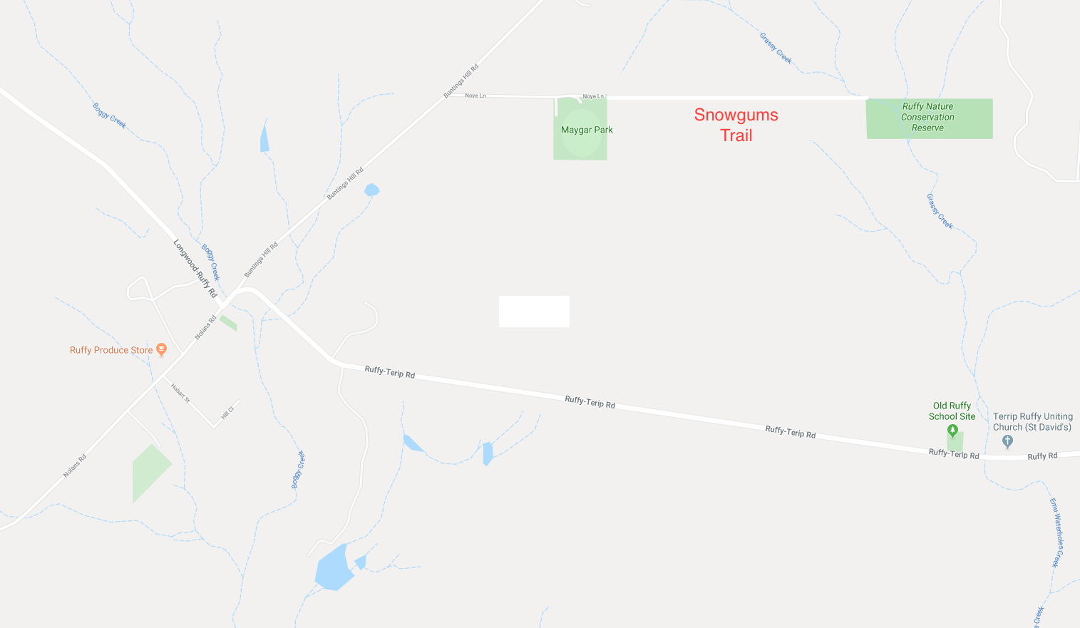
 Extends from Noyes Lane, Ruffy.
This track meanders down an unused road reserve through open Narrow-leaf Peppermint forest until it crosses a walking bridge and enters the Ruffy Flora Reserve. A circuit of this reserve takes you through swampy riparian woodlands dominated by ancient Mountain Swamp Gums. The path continues past a tiny population of Snow Gums, remnants of a colder climate, and skirts a chain of dark deep billabongs into bandicoot and koala territory.
Responsible Authority:
Road Reserve: Strathbogie Shire Council
Ruffy Nature Conservation Reserve: DELWP
Acceptable modes of transit:
Walk (mountain bike and horse with track improvement)
Distance & duration
3km return, 1.5hrs to the Reserve.
Additional loops could be added:
GPS coordinates & map
36°58′4″ S 145°30′56″ E
-36.967745, 145.514873
Grading (using the Parks Vic Track and Trail Grading Manual):
Grade 3. Flat, but with some uneven ground and open woodland debris underfoot. Could be rated easy with trail clearance.
Amenities:
The walk commences at the Ruffy Recreation Ground, Maygar Park.
Parking at the Ruffy Recreation Ground
Shelter and picnic facilities at the Recreation Ground
Toilets at the Ruffy Recreation Ground
Horse containment at the Recreation Ground
Hazards
Tree & branch falls, uneven surfaces, bogs, flowing water, snakes
Restrictions
Take your rubbish with you
No potable water
Trailhead sign & Informational Signs
No trailhead sign in situ (there is one in poor condition that has been removed).
Directional signs / bollards or trail markers
No directional signs on nearby roads
No trail markers along the trail, but some exist within the Reserve
Brochure
Available
Conclusion
This trail has the potential to be a key feature for visitors to Ruffy. With some basic work, it could be improved considerably. This trail is currently accessible to walkers and is in occasional use. However, until the trail has been cleared for snake sighting, recommended use is probably best confined to the cooler months. With improvement, it would be a viable all year walking, mountain bike and horse trail.

The welcome arrival of Lesley, Marie and Michele usually leads to a walk. Today was no exception. Since they were on the way back to Melbourne this afternoon, the time between lunch and departure was fairly tight. We needed a route, preferably a circuit, of around 5km. At 5.05km, this loop fitted the bill.
Starting at the corner of Nicholls Lane and Jukes Rd we headed toward the Strathbogie Merton Rd on a gentle downward gradient. The dirt had been recently graded smooth to the driveway of the only farm house. This was a just few hundred metres down the 900m lane. Beyond was a pretty, little used, leaf-littered, dusty grey track. This track cut between dry woodland above. Below is a rustic dell including a rush bordered pond within romantic farmland, submerged in forest.
Turning left into the Strathbogie-Merton Rd began a modest incline on narrow winding white gravel. This road is closely skirted by forest across steep slopes and within deep gullies. All are dotted with beautiful, lichen draped granite boulders and formations. The grey green of eucalyptus leaves is set against the walls of white trunked manna gums. The salmon patches exposed by long strips of ribbon bark falling to the ground create a glorious summer palette.
Cresting the top of the rise, we made the transition to the rolling hills of wood bound farmland. The cultivated top of the Tableland. From there it was downhill to the Jukes Rd intersection. There is a short stretch of bitumen to the sharp “V” where the roads meet. Jukes Rd takes off up the hill in a climb that has to recover the previous loss of elevation. It is enough to get the heart rate going if you push it.
The usual wildlife presented. However, unusually, we saw a wallaby chasing a hare as they both bounded down the slope and over the road in front of us! Something I can’t explain. A white throated tree creeper was spotted working the tree trunks. Currawongs chimed and kookaburras laughed at our passage with gusto. We startled a pair of common bronze wing pigeons into a panicked flight. They looked very guilty. A large echidna was foraging in the bush, but dug in deeply before Marie could get a good look. Very sensible with Marie around! Three swamp wallabies suspiciously watched our progress from behind a fallen log. They looked like they were waiting to ambush someone, but fortunately it wasn’t us.
This was a very pleasant walk. A fairly steep rise through the manna, narrow leafed peppermint and stringy-bark forest to the peak would make an interesting side expedition. However, the tree clad crown might not lend itself to a view.

Mode of Transit: Walk
Distance from Melbourne: 150km
Location: Strathbogie Township & surrounds
GPS coordinates: Start and finish 35 51’ 13” S 145 44’ 45” E
Map:

Environmental status: 1km Main and Armstrong Streets, Strathbogie – built environment, golf course and pasture.
2.5km bushwalk in Sevens Creeks Wildlife and Bridge to Bridge Reserves – high quality habitat comprising healthy riparian zones.
Elevation: 485m
Degree of difficulty: gradient some short steep rises, rocky outcrops, otherwise easy walking, but requires sure-footedness
Distance: 3.5km circuit
Duration: 1.5hrs
Facilities: General store open 7 days. Public toilets at local Recreation Ground 0.5km up Spring Creek Rd from Spring Creek Bridge
Take: hat, sunblock, sturdy walking shoes, water, camera, phone
Features:
1. Topography: modestly undulating, short steep slopes, rocky and earthen embankments
2. Surface: engineered gravel footpath to bitumen roadway to unmarked and absent dirt trails and rocky outcrops to grassy pathway with uneven ground
3. Waterways: Seven Creeks, turbid permanent water, meandering across flood plains or cascading through rocky terrain with sandy beaches and lazy pools
Spring Creek, clear, sandy or rock bottomed permanent water with cascades running under Spring Creek Bridge
4. Flora: open woodland including significant stands of established swamp, narrow leafed peppermint, manna gums with poa meadows. Extensive decade old Strathbogie Landcare plantings of indigenous trees and shrubs. Occasional, dispersed woody weed clumps (principally blackberry) along the Sevens, but severe around the Goulburn Valley Water Treatment Plant (which they have agreed to correct). Bridge to Bridge is largely woody weed free.
5. Fauna: indigenous wildlife is common, including native fish, birds, koalas, echidnas, wombats, eastern greys, swamp wallabies, rakali, bobucks, snakes, lizards and platypus
6. Natural environment: healthy riparian zone
7. Built environment: Township zone and riparian bush zone with few nearby farmhouses
8. Safety: animal burrows, slippery surfaces, uneven ground, snake habitat, discarded wire
Comments: with the comfort of access to the Strathbogie Store, this short, beautiful walk can be undertaken with little in the way of carried provisions and much to see. Opportunities for candid wildlife image captures are likely.
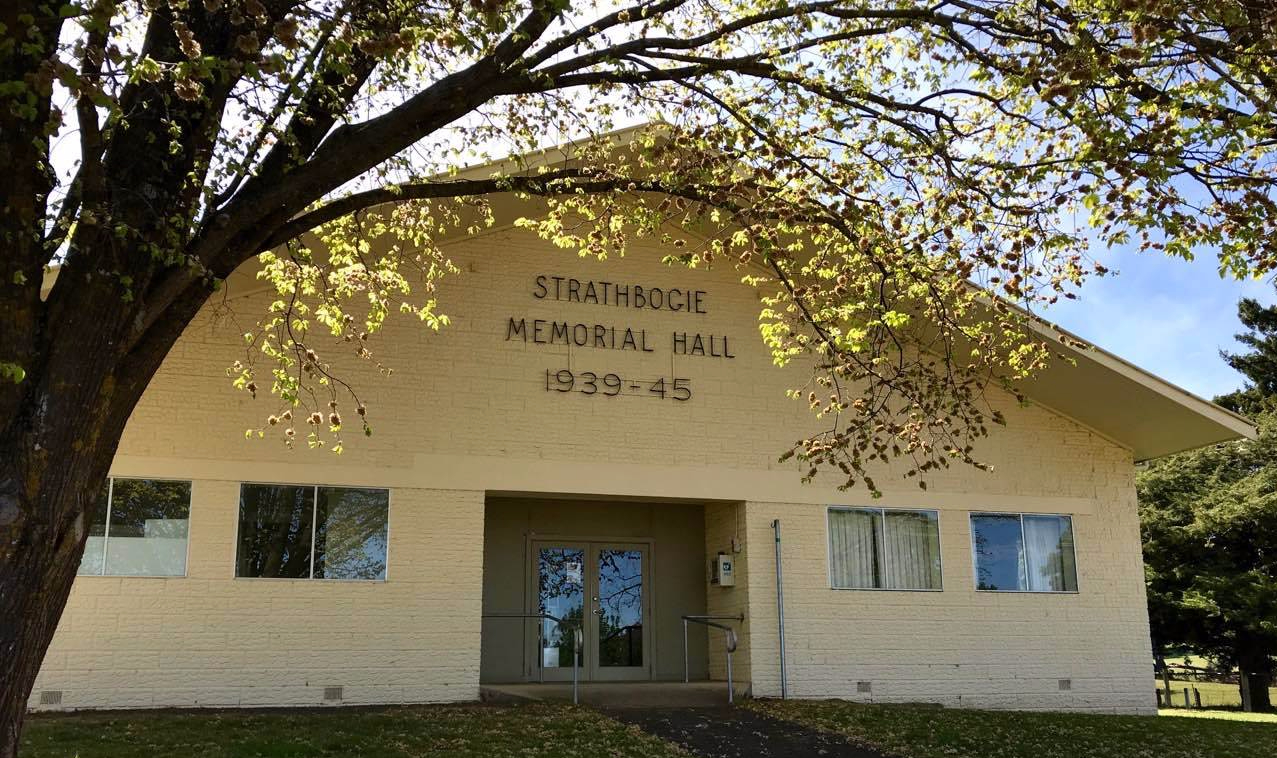
Directions: Commence at the Spring Creek Bridge, walking up Main St until you reach the Strathbogie Memorial Hall at Armstrong St. Turn left and walk along Armstrong St, you will pass the town water tower on the right and golf course entrance on the left. Keep walking until you arrive at the the disused bridge (completely unsafe to cross). 10 metres before the bridge on the right is a gap in the fence between 2 large posts. Enter the Seven Creeks Wildlife Reserve here. The trail can disappear. You will best pick it up by keeping close to the fence line on the higher side of the slope, deviating to and returning from features that attract you. There is no need to cross the creek. Follow the trail until you get to the Goulburn Valley Water Treatment Plant. Walk under Smith’s Bridge to enter the Bridge to Bridge Picnic Ground and Track. This end of the Bridge to Bridge is a short nature circuit. Either arm of the track will take you to a boardwalk from where you can continue your return to the Spring Creek Bridge via the confluence of Seven and Spring Creeks.
Images:

Nearby Tracks & Trails: Seven Creeks Wildlife Reserve to Brookleigh Rd. Proposed Magiltan Project upstream of Spring Creek to Magiltan Creek.
Links to The Great Strathbogie Trail: along the length of the Seven Creeks Wildlife Reserve
Ideas for improvement: woody weed control, trail markers, directional and safety entry signs, some basic trail work to flatten angled slopes
This gallery contains 16 photos.
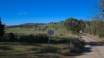
a very peaceful rural walk through pretty agricultural landscapes with granite outcrops and views across bush slopes to The Paps and Mt Buller Continue reading
 We are on a journey here. I mean, we are on all kinds of journeys of course, but this one is quite specific. This is a physical journey, one for travelling together. We have tasked ourselves with walking the roads, tracks and trails of the Strathbogie Tableland. Sometimes 4km, sometimes 15, every time something new to experience. Even when we repeat a path there will be a seasonal difference, something that has changed in the landscape surrounding us or something that has changed about ourselves that we take to each place.